l Home l Galveston Hurricane 1900 l Galveston Research l Galveston Supporting Resources l Galveston References l Galveston Team Reflection l

Groupmates... Please place your questions in the appropriate categories.
Opening Statement: (Raul) As a group of will discuss how the Galveston Hurricane of 1900 affected the city of Galveston. We will research on how the catastrophe changed the city of Galveston and what can be done to prevent a similar incident that included major loss of life and infrastructure. In addition, we will work together to come up with recommendations and possible policy to back up our findings. The project is a collaborative effort and our group will note our findings on our group wiki page.
Recommendations: (Raul) After collaborating we have concluded that various resources have supported our theories and we recommend the need for hurricane prone cities to maintain precise emergency preparation and evacuation plans as well as invest in infrastructure that will minimize loss of life and destruction in the event of a major hurricane.
General Information: (Raul) The occurrence of the Galveston Hurricane of 1900 provided necessary benefits, negative economic impacts, as well as solutions that would help shape the future of the city of Galveston, Texas.
Benefits: (Raul) What is Galveston’s current infrastructure in place to prevent major damage from a hurricane direct hit?
To prevent future storms from causing destruction like that of the 1900 hurricane, many improvements to the island were made. The first three miles (4.8 km) of the 17 foot (5.2 m) high Galveston Seawall were built beginning in 1902 under the direction of Henry Martyn Robert. An all-weather bridge was constructed to the mainland to replace the ones destroyed in the storm.
The most dramatic effort to protect the city was its raising. Dredged sand was used to raise the city of Galveston by as much as 17 feet (5.2 m) above its previous elevation. Over 2,100 buildings were raised in the process, including the 3000 ton St. Patrick's Church. The seawall and raising of the island were jointly named a National Historical Civil Engineering Landmark by the American Society of Civil Engineers in 2001.
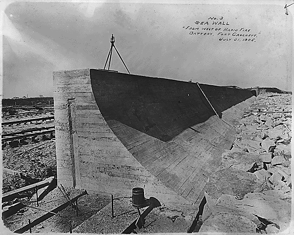
To prevent future storms from causing destruction like that of the 1900 hurricane, many improvements to the Galveston Sea Wall were made, such as extensions and reinforcements.
Galveston Sea Wall Image Retrieved from http://www.absoluteastronomy.com/topics/Galveston_Hurricane_of_1900.
Read, B. (September 2005). The galveston hurricane of 1900. Retrieved from http://economistsview.typepad.com/economistsview/2005/09/the_galveston_h.html.
Video showing the current, updated infrastructure and how it held up with recent major hurricane Ike: Retrieved from http://www.msnbc.msn.com/id/30951045/ns/us_news-life/t/galveston-still-hurting-hurricanes-beating/
Economic: (Raul) What impacts did the Galveston Hurricane of 1900 have on the city of Galveston?
Prior to the Hurricane of 1900, Galveston was considered to be a beautiful and prestigious city and was known as "the New York of the South." Only the nation's wealthiest were allowed to live there. Many people say that had it not been for the hurricane, Galveston would today be one of the nation's largest and most beautiful cities. However, development shifted north to Houston, which was enjoying the benefits of the oil boom. The dredging of the Houston Ship Channel in 1909 and 1914 ended Galveston's hopes of returning to its former state as a major industrial center.

Table showing Galveston Hurricane of 1900 as the 2nd most costliest hurricane in history of US Atlantic Hurricanes: Retrieved from http://wattsupwiththat.com/2010/05/28/your-tax-dollars-at-work-study-concludes-major-hurricane-could-devastate-houstongalveston-region/.
Read, B. (September 2005). The galveston hurricane of 1900. Retrieved from http://economistsview.typepad.com/economistsview/2005/09/the_galveston_h.html.
Solutions: (Raul) What changes has the city of Galveston implemented since the Hurricane of 1900 in order to better prepare the city for a catastrophic event?
The Galveston city government was reorganized into a commission government, a newly devised structure where the government is made of a small group of commissioners, each responsible for one aspect of governance. This was prompted by fears that the existing city council would be unable to handle the problem of rebuilding the city.
Today Galveston is considered the playground of Houston. Homes and other buildings that survived the hurricane have been preserved, and give much of the city a Victorian look. The seawall, since extended to ten miles (16 km), is now an attraction itself, as hotels and tourist attractions have been built along its length in seeming defiance of future storms.
The costly attempt has been made to minimize the possibilities of catastrophic losses in cities such as Galveston by presenting proactive preparedness plans and changes to infrastructure and topography in areas that might be affected by these future hurricanes.
Read, B. (September 2005). The galveston hurricane of 1900. Retrieved from http://economistsview.typepad.com/economistsview/2005/09/the_galveston_h.html.
Solutions: (Shannon) Now with satellites and technology what efforts are put in place to warn residents?
Tracking Hurricanes
Tracking tropical cyclones is a constantly evolving science. Different methods include using satellites and radar, and reconnaissance aircraft. Observations from across the Caribbean also greatly assist in tracking tropical cyclones.
Satellites
Prior to the technology used to develop and launch satellites, it was difficult for meteorologists to determine just where tropical cyclones were forming. They relied on ship and tropical island weather observations and coastal radars.
The first satellite launched by the United States to monitor weather conditions was TIROS in 1960. TIROS' capabilities are primitive compared to today's satellite technology, but it opened the door for meteorologists to understand a great deal more about tropical cyclones.
Satellite images are very important to forecasters because by putting into motion several hours of satellite pictures, they can gather information about the track and development of the tropical cyclone.
The newest generation of weather satellite is the GOES (Geostationary Operational Environmental Satellites) series. The two operational GOES satellites, GOES-East and GOES-West, operate together to send overlapping images of the Western Hemisphere, which help forecasters monitor Atlantic and Eastern Pacific tropical cyclones.
Doppler Radar
Doppler radar can detect rain associated with tropical cyclones. It typically covers rain within a 200-250 mile distance from the radar location and provides estimates of rainfall amounts and depicts a hurricane's rain bands, its eye, and its eye wall.
http://www.weather.com/encyclopedia/tropical/tracking.html
Hurricane Tracker Apps for iPad, iPhone, Android.
http://abcnews.go.com/Technology/hurricane-irene-apps-ipad-iphone-ipod-track-storm/story?id=14355766
Dust & the Hydrosphere E > H (Patricia)
Dust & the Atmosphere E > A (Jose) What was the most intense hurricane to strike the US?
Over the Labor Day weekend in 1935, a hurricane struck the Florida Keys. With record-setting low barometric pressure of 892 mb, the tiny island of Islamorada had little chance of avoiding annihilation. 390 died in the event, as the Keys were not yet very populated. Roads, buildings, viaducts, bridges and the railroad were completely wiped out. The Labor Day Hurricane sustained winds are estimated to have reached almost 200 miles per hour.
The Ten Strongest Hurricanes
The Ten Worst Hurricanes As Measured By Intensity
1. The Great Labor Day Storm
September 2, 1935
Florida
One of just three Category 5 Hurricanes to make landfall in the US, the Great Labor Day Storm had a minimum pressure of 892 millibars (26.35 inches). It caused 423 deaths in Florida. It also was notable for providing the setting for the Humphrey Bogart - Lauren Bacall movie, Key Largo.
2. Hurricane Katrina
August, 2005
Louisiana and Mississippi
Katrina had a minimum pressure of 904 millibars (26.64 inches), making it the second most intense storm to hit the US, as well as the most costly, and the third deadliest.
3. Hurricane Camille
August 17 - 22, 1969
Mississippi, SE Louisiana, Virginia
Camille, a Category 5, was the second most intense Hurricane ever to hit the United States, with a minimum pressure of 909 millibars (26.84 inches). The final wind speed will never be known because all measuring devices were destroyed, but it is thought to exceed 200 mph.
4. Hurricane Andrew
August 24 - 28, 1992
Florida and Louisiana
A Category 4 when it hit Florida, Hurricane Andrew hit Louisiana as a Category 3. At its peak, Andrew had a minimum pressure of 922 millibars (27.23 inches).
5. Unnamed Hurricane
August 29, 1886
Indianola, Texas
This Category 4 Hurricane turned Indianola into a Ghost Town. Today, the Court House lies 300 feet out in Matagorda Bay. The storm had a recorded minimum pressure of 925 millibars (27.31 inches).
6. The Atlantic-Gulf Hurricane
Florida, Texas
September 10 - 14, 1919
This hurricane struck the Keys as a Category 4, and Texas as a Category 3. At its peak, it had a minimum pressure of 927 millibars (27.37 inches).
7. San Felipe-Okeechobee Hurricane
September 16 - 17, 1928
Florida
The fourth strongest Hurricane to hit the US mainland caused a lake surge on the inland Lake Okeechobee in Florida that rose as high as nine feet, flooding nearby towns. A Category 4, it had a minimum pressure of 929 millibars (27.43 inches)
8. Hurricane Donna
September 8 - 13, 1960
Florida to New England
Donna is the only hurricane known to have produce hurricane-force winds in Florida, the Mid-Atlantic states, and New England. At its peak, it had a minimum pressure of 930 milibars (27.46 inches).
9. Unnamed Storm
September 30, 1915
New Orleans, Louisiana
This unnamed Category 4 Storm reached a minimum pressure of 931 millibars (27.49 inches). It flooded Lake Pontchartrain, causing it to overflow its banks and killing 275 people.
10. Hurricane Carla
September 11, 1961
Texas
A Category 4, Carla had a minimum pressure of 931 millibars (27.49 inches), tying it with the 1915 Louisiana storm.
Labor Day 1935 Hurricane Monthly Weather Review Article. W. F. McDonald. Retrieved November 10, 2011 from http://www.aoml.noaa.gov/hrd/Storm_pages/labor_day/labor_article.html
Epic Disasters: The World's Worst Disasters. Retrieved November 10, 2011 from http://www.epicdisasters.com/index.php/site/comments/the_ten_strongest_hurricanes/
Dust & the Atmosphere: (Shannon) In the 20th century, how many hurricanes hit the US?
158 hurricanes hit the US from all categories; 64 of these were major hurricanes, categories 3-5. Florida had the most landfalls at 57, with the majority of these being in the northwest and southeast. Texas came in second with 36, and Louisiana and North Carolina tie for third at 25 a piece.
http://www.aoml.noaa.gov/hrd/tcfaq/E19.html
Hurricane direct hits on the mainland U.S. coastline and
for individual states by Saffir/Simpson category
1851-2009
| AREA | CATEGORY | Major Hurricanes |
||||||
| 1 | 2 | 3 | 4 | 5 | ALL | |||
| U.S. Coastline (Texas to Maine) |
115 | 76 | 76 | 18 | 3 | 288 | 97 | |
| Texas | 25 | 19 | 12 | 7 | 0 | 63 | 19 | |
| North | 13 | 8 | 3 | 4 | 0 | 28 | 7 | |
| Central | 7 | 5 | 2 | 2 | 0 | 16 | 4 | |
| South | 10 | 5 | 7 | 1 | 0 | 23 | 8 | |
| Louisiana | 18 | 15 | 15 | 4 | 1 | 53 | 20 | |
| Mississippi | 2 | 5 | 8 | 0 | 1 | 16 | 9 | |
| Alabama | 12 | 5 | 6 | 0 | 0 | 23 | 6 | |
| Florida | 44 | 33 | 29 | 6 | 2 | 114 | 37 | |
| Northwest | 27 | 16 | 12 | 0 | 0 | 55 | 12 | |
| Northeast | 13 | 8 | 1 | 0 | 0 | 22 | 1 | |
| Southwest | 16 | 8 | 7 | 4 | 1 | 36 | 12 | |
| Southeast | 13 | 13 | 11 | 3 | 1 | 41 | 15 | |
| Georgia | 12 | 5 | 2 | 1 | 0 | 20 | 3 | |
| South Carolina | 19 | 6 | 4 | 2 | 0 | 31 | 6 | |
| North Carolina | 22 | 13 | 11 | 1 | 0 | 46 | 13 | |
| Virginia | 9 | 2 | 1 | 0 | 0 | 12 | 1 | |
| Maryland | 1 | 1 | 0 | 0 | 0 | 2 | 0 | |
| Delaware | 2 | 0 | 0 | 0 | 0 | 2 | 0 | |
| New Jersey | 2 | 0 | 0 | 0 | 0 | 2 | 0 | |
| Pennsylvania | 1 | 0 | 0 | 0 | 0 | 1 | 0 | |
| New York | 6 | 1 | 5 | 0 | 0 | 12 | 5 | |
| Connecticut | 4 | 3 | 3 | 0 | 0 | 10 | 3 | |
| Rhode Island | 3 | 2 | 4 | 0 | 0 | 9 | 4 | |
| Massachusetts | 5 | 2 | 3 | 0 | 0 | 10 | 3 | |
| New Hampshire | 1 | 1 | 0 | 0 | 0 | 2 | 0 | |
| Maine | 5 | 1 | 0 | 0 | 0 | 6 | 0 | |
Dust & the Biosphere E > B (Jose) - How often do major hurricanes hit the US?
It varies from year to year, but the average number of Atlantic hurricanes per year since 1995 is about 8 with 15 named storms. NOAA does not make an official seasonal hurricane landfall outlook. Predicting where and when hurricanes will strike is related to daily weather patterns, which are not reliably predictable weeks or months in advance. Therefore, it is currently not possible to reliably predict the number or intensity of land falling hurricanes at these extended ranges, or whether a given locality will be impacted by a hurricane this season.
But remember that it only takes one storm hitting your area to cause a disaster, regardless of the overall activity predicted in this outlook. Therefore, residents, businesses, and government agencies, of coastal and near-coastal regions are urged to prepare every hurricane season regardless of this, or any other, seasonal outlook.
Consistent with the expected ACE range, the 2011 Atlantic hurricane season is predicted (with 70% chance) to produce 14-19 named storms, of which 7-10 are expected to become hurricanes, and 3-5 are expected to become major hurricanes. On average, two major hurricanes (cat 3-5) strike every three years; in all categories, about five hurricanes make landfall every three years. On average, a hurricane Category 4 or higher only strikes once every six years. 2004 has been an anomaly.
NOAA 2011 Atlantic Hurricane Season Outlook Update. Retrieved November 10, 2011 from http://www.cpc.ncep.noaa.gov/products/outlooks/hurricane.shtml.
Dust & the Geosphere E > G (Gladys)
Research Plan: (Shannon)
The following people will tackle the above questions –
• Raul: General Information/Opening Statement/Recommendations/Problem Statement
• Gladys: Galveston & Geosphere
• Jose: Galveston & Atmosphere/Biosphere
• Patricia: Galveston & Hydrosphere/Research Plan Statement
• Shannon: Research Plan/Bibliography
Research Plan Statement: (Patricia)
Problem Statement: (Raul)
After researching and compiling expert and critical data analysis on the intensity and frequency of hurricanes in the Gulf of Mexico, our team will present data and propose policy to bring to light the possibility of more frequent and intense hurricanes in the future in the Galveston area. We will also try to minimize the possibilities of catastrophic losses in cities such as Galveston by presenting proactive preparedness plans and changes to infrastructure and topography in areas that might be affected by these future hurricanes.
Bibliography: (Shannon)
References
Galveston Hurricane of 1900. (2011). Retrieved November, 2011, from AbsoluteAstronomy.com website: http://www.absoluteastronomy.com/topics/Galveston_Hurricane_of_1900
Galveston Hurricane 1900. (2006, September). Retrieved November, 2011, from Tides for Teachers website: http://144.96.123.227/Teachers/Tides/docs/LessonPlans/Elementary/socialPlans/GarciaGalveston
Galveston Hurrican of 1900. (n.d.). Retrieved November, 2011, from Texas State Historical Association website: http://www.tshaonline.org/handbook/online/articles/ydg02
Galveston Newspapers Inc. (2011). Film Clips. In The 1900 Storm Galveston Island, Texas. Retrieved November, 2011, from Galveston County Daily News website: http://www.1900storm.com/film/
Gil, K. (2005, September 19). US Cities Hit Most Often By Tropical Storms & Hurricanes. Retrieved November, 2011, from http://uspolitics.about.com/od/energy/a/most_hurricanes.htm
Hurricanes. (n.d.). Retrieved November, 2011, from FEMA website: http://www.ready.gov/hurricanes
Hurricanes and Tropical Storms. (n.d.). Retrieved November, 2011, from The Weather Channel website: http://www.weather.com/encyclopedia/tropical/tracking.html
Johnson, A. (2009, June 1). Galveston still hurting from hurricane’s beating [Motion picture]. Retrieved from msnbc.com and NBC News database.
Landsea, C. (2001). Hurricane Research Division. In How many direct hits by hurricanes of various categories have affected each state? . Retrieved November, 2011, from Atlantic Oceanographic & Meteorological Laboratory website: http://www.aoml.noaa.gov/hrd/tcfaq/E19.html
Lester, P. (n.d.). The great Galveston disaster, containing a full and thrilling account of the most appalling calamity of modern times including vivid descriptions of the hurricane. Retrieved November, 2011, from The Portal to Texas History website: http://texashistory.unt.edu/ark:/67531/metapth26719/m1/1/
Read, B. (2005, September). The Galveston Hurricane of 1900. Retrieved November, 2011, from Economist’s View website: http://economistsview.typepad.com/economistsview/2005/09/the_galveston_h.html
Smith, A. (2011, August 22). Hurricane Tracker Apps for iPad, iPhone, Android to Avoid Irene. Retrieved November, 2011, from ABC News database.
State of the Climate Global Analysis Annual 2007. (n.d.). Retrieved November, 2011, from NOAA Satellite and Information Service website: http://www.ncdc.noaa.gov/sotc/global/2007/13
Thiesen, W. H., PhD. (n.d.). The Galveston Life-Saving Station, September 1900: The Anatomy of a Super-Hurricane and the Perils of Working for the United States Life-Saving Service. Retrieved November, 2011, from United States Coast Guard website: http://www.uscg.mil/history/articles/GalvestonUSLSSGalveston.pdf
Thiesen, W. H., PhD. (n.d.). The 1900 Galveston Hurricane and the Activities of U.S. Lighthouse Service Personnel in America’s Worst Natural Disaster. Retrieved November, 2011, from http://www.uscg.mil/history/articles/Galveston1900KeepersLog.pdf
Watts, A. (2010, May 28). Study concludes: “major hurricane could devastate the Houston/Galveston region”. Retrieved November, 2011, from Watts Up With That? website: http://wattsupwiththat.com/2010/05/28/your-tax-dollars-at-work-study-concludes-major-hurricane-could-devastate-houstongalveston-region/